
| Ma'lumot | |
|---|---|
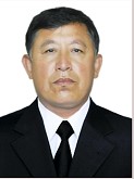 |
Head of Department ALIQULOV G‘OLIB NARTOSHEVICH Telefon: +99893-697-20-19ch |
“GEODESY AND GEOINFORMATICS”
The Department of “Geodesy and geoinformatics” was founded in 1977 on the basis of the Department of General Technical Disciplines of the Karshi Branch of the Tashktnt Institute of Irrigation and Agricultural Mechanization Engineers. The department began its activity on January 10, 2010. In 2020, two departments were created on the basis of the department: "Geodesy, Cadastre and Land Use" and "Mining".
In accordance with the Decree of the President of the Republic of Uzbekistan No. PP-428 "On the organization of the Karshi State Technical University" dated December 10, 2024, in connection with the establishment of the Karshi State Technical University, the department was renamed as the Department of Geodesy and Geoinformatics. Over the years, the department was headed by doctor of economics, professor S. Avezboev, doctor of technical sciences, professor M. Avlakulov, candidate of economic sciences, associate professor M. Bozorov, doctor of technical sciences, associate professor R. Eshonkulov.
The department trains specialists in the bachelor's degree programs 60722500-“Geodesy, Cartography and Cadastre”, 5410700-“Land Cadastre and Land Use”, 60722800-Cadastre (Real Estate Cadastre) and in the master's degree program 70722801-Cadastre (Unified System of State Cadastres).
The Department of Geodesy and Geoinformatics is a structural division of the Karshi State Technical University. During the academic year, in order to improve the quality and qualifications of educational classes, professors and teachers with high scientific potential from leading universities in Uzbekistan and abroad are involved in the educational process on an hourly basis. The main objective of the department is to train and educate highly qualified specialists and, first and foremost, individuals with high spirituality and a broad worldview.
In this area, professors and teachers of the department conduct training sessions, and carry out extensive explanatory work with students during lectures, practical and laboratory classes on work carried out in geodesy, cartography and the cadastral service.
Students' qualification internships are conducted at such large enterprises as the State Scientific and Production Institution "Uzdaverloyikha", the Kashkadarya Regional Office of the Cadastral Chamber, the Kashkadarya Regional Office of the Cadastral Agency and its regional branches.
Department Structure and Its Research Potential
The department has 25 full-time faculty members, including five professors and lecturers with advanced degrees. The department's research potential accounts for 20.0%.
| № | Professor-o‘qituvchilarning F.I.SH. | Lavozimi |
|---|---|---|
| Alikulov Golib Nortoshevich |
PhD in agricultural sciences, associate professor |
|
| 1. | Zuxurov Yigitali Tog‘ayevich | doctor of philosophy in pedagogical sciences (PhD), acting. associate professor |
| 2. | Jumanov Bekzod Norboyevich | senior lecturer |
| 3. | Berdiyev Dilshod Faxriddin o‘g‘li | senior lecturer |
| 4. | Avilova Nilufar Fayzulla qizi | senior lecturer |
| 5. | Safarov Fayzali Saminqulovich | senior lecturer |
| 6. | Mirzayev Jonibek Oltiyevich | assistant |
| 7. | Qilichev Zaynobiddin Mirzayevich | assistant |
| 8. | Bozorov Malik Maxmudovich | assistant |
| 10. | Muzropova Fazilat Ibrohim qizi | assistant |
| 11. | Fayzullayeva Lobar Xayrullo qizi | assistant |
| 12. | Davlatov Xayitboy Nabijon o‘g‘li | assistant |
| 13. | Haqberdiyev Alisher Eshmamatovich | assistant |
| 14. | Meyliyeva Xodicha Faxriddin qizi | assistant |
| 15. | Shog‘darov Doniyor Dilshod o‘g‘li | assistant |
| 16. | Nazarov O'lmas Azamat o`g`li | assistant |
| 17. | Xudoynazarova Mavluda Abduvohid qizi | kyzy, assistant |
| 18. | Baxriyev Muxammad Baxtiyor o'g'li | assistant |
| 19. | Haqqulova Adiba Ochil qizi | intern teacher |
| 20. | Asadov Shahzod Umidillayevich | intern teacher |
| 21. | Axmatov Abutolib Ochilxon o'g'li | intern teacher |